Welcome to Grid references & Co-ordinates Day!
Breadth of Study:
- Geographical skills and fieldwork
Objectives:
- to build their knowledge of the local area and the world, by using:
- the eight points of a compass
- four and six-figure grid references
- symbols and key (including the use of Ordnance Survey maps)
Session One:
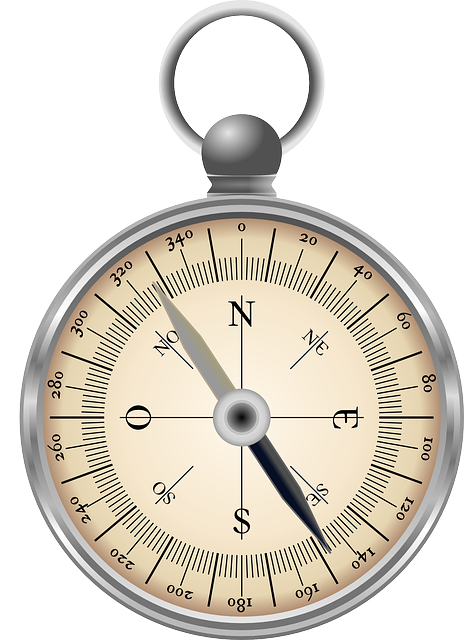
The Compass
A compass is an instrument used for navigation and orientation that shows direction.
A diagram called a compass rose shows the directions north, south, east, and west on the compass face as abbreviated initials N, S, E, and W.
Compasses often display markings for angles in degrees in addition to (or sometimes instead of) the rose and the angles increase clockwise.
- North corresponds to 0°
- East is 90° degrees
- South is 180°
- West is 270°.
These numbers allow the compass to show magnetic North or true North.
The magnetic compass was first invented during the Chinese Han Dynasty (since c. 206 BC).
The first usage of a compass recorded in Western Europe and the Islamic world occurred around 1190.
There is a previous activity on making a compass here http://narloh.com/magnet-day/
Limitations of the magnetic compass
- In geographic regions near the Earth’s magnetic poles a compass becomes unusable. As the compass is moved closer to one of the magnetic poles, the difference between the direction to geographical north and magnetic north, becomes greater and greater. At some point close to the magnetic pole the compass will not indicate any particular direction but will begin to drift.
- Magnetic compasses are influenced by magnetic mineral deposits, MRIs, large iron or steel bodies.
- A compass is also subject to errors when the compass is accelerated or decelerated in an airplane or automobile.
Learning the Compass Rose Points
Activity One (inside):
Activity Two (inside ):
Practicing Using a Basic Compass Rose.
Using the compass rose as a reference, do this simple compass point trip.
- Using a piece of graph paper, draw an arrow in the corner to indicate north, as indicated below.
- Choose a starting point in the center of the paper, make a dot and label it Start.
- Begin at Start and try to reach Finish by following the directions below.
- 2 squares N
- 4 squares E
- 1 square S
- 2 squares W
- 2 squares S
- 6 squares E
- 3 squares N
- 2 squares SW
- 1 square W
- 2 squares N
- 1 square NE
- Mark the final square Finish.
- Check that everyone has the Finish in the same place.
Activity Three (outside):
DIRECTION FACING
- Go outside and stand in a space.
- Find North on your compass.
- You have 10 points.
- I am going to shout out a direction and the last person to face that direction loses a point.
- The person with the most points at the end (agreed number of directions) wins.
Using a Compass
Activity Four (outside – large space):
COMPASS WALK
Materials: for each pair, a compass, an individually wrapped piece of candy /snack bar.
Method: In a large outdoor area, the second person is blind-folded while the first person sets his/her compass at 360º, faces north, and walks for 50 paces following that bearing. Next, she/he sets his compass for 120º, faces that bearing and takes another 50 paces. Finally, she/he sets his compass for 240º, faces that bearing, and again takes 50 paces, then places the candy on the ground.
The second person follows the same directions to find the candy.
Repeat in reverse with first person blind-folded.
Activity Five (inside):
If you don’t remember about latitude and longitude check here.
Latitude and Longitude Worksheet
Session Two:
Four Figure Grid References.
Read about how to write 4 figure grid references here.
Activity Six (inside):
Four-figure grid references worksheet
Session Three:
Symbols and Keys
Activity Seven (inside):
Session Four:
Six Figure Grid References.
Activity Eight (outside):
We are going to follow this route (Worksheet), add the landmarks along the way, and take photos.
Extension:
Ordinance Survey Maps
Ordnance Survey (OS) is the national mapping agency for Great Britain. The agency’s name indicates its original military purpose which was to map Scotland in the wake of the Jacobite rising of 1745. There was also a more general and nationwide need in light of the potential threat of invasion during the Napoleonic Wars.
Ordnance Survey mapping is usually classified as either “large-scale” (in other words, more detailed) or “small-scale”.
USNG
The USA doesn’t have anything as consistent and simple as the Ordnance Survey, but it does have the National Grid. Minnesota is the Currently, only the state of Minnesota provides a comprehensive series of USNG maps for the entire state. These maps provided a viewing space based on 10KM (kilometer) grids. Follow-up paper activities on maps, co-ordinates, and symbols. I would love to show you an introductory video or simple presentation but the whole USNG website is full of broken links and outdated PDFs. Maybe you want to make a video about it later.
Here is the MN USNG site –MNGEO – you can zoom in and find the co-ordinates for home. You will notice the layout is in dire need of attention.
Session Five – Wrap-up:
Collate your map work, staple it together, and make a cover page with a Title such as ‘Co-ordinates Day’ or something jazzy but meaningful.
Quiz to come.