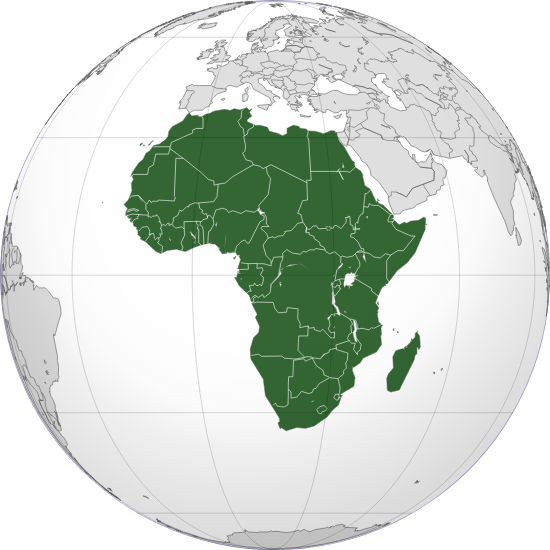
The Global Tapestry of Africa (1200 to 1450)
Africa Today in Facts and Numbers
Largest and Smallest Countries in Africa
Algeria is the largest nation in Africa by area.
Nigeria is Africa’s most populous country.
Seychelles are the smallest country in Africa by both size and population.
Bodies of Water in Africa
Lake Tanganyika is the deepest lake in Africa and is the largest among the Albertine Rift lakes.
Lake Victoria, largest lake in Africa and chief reservoir of the Nile, lying mainly in Tanzania and Uganda but bordering on Kenya.
Hottest and Coldest Places in Africa
Dallol (Ghost Town) currently holds the official record for record high average temperature for an inhabited location on Earth.
Temperatures are hottest (for an uninhabited area) within the Sahara regions of Algeria and Mali.
Lesotho, a landlocked country completely surrounded by South Africa, is the coldest country in Africa.
Africa 1200 to 1450
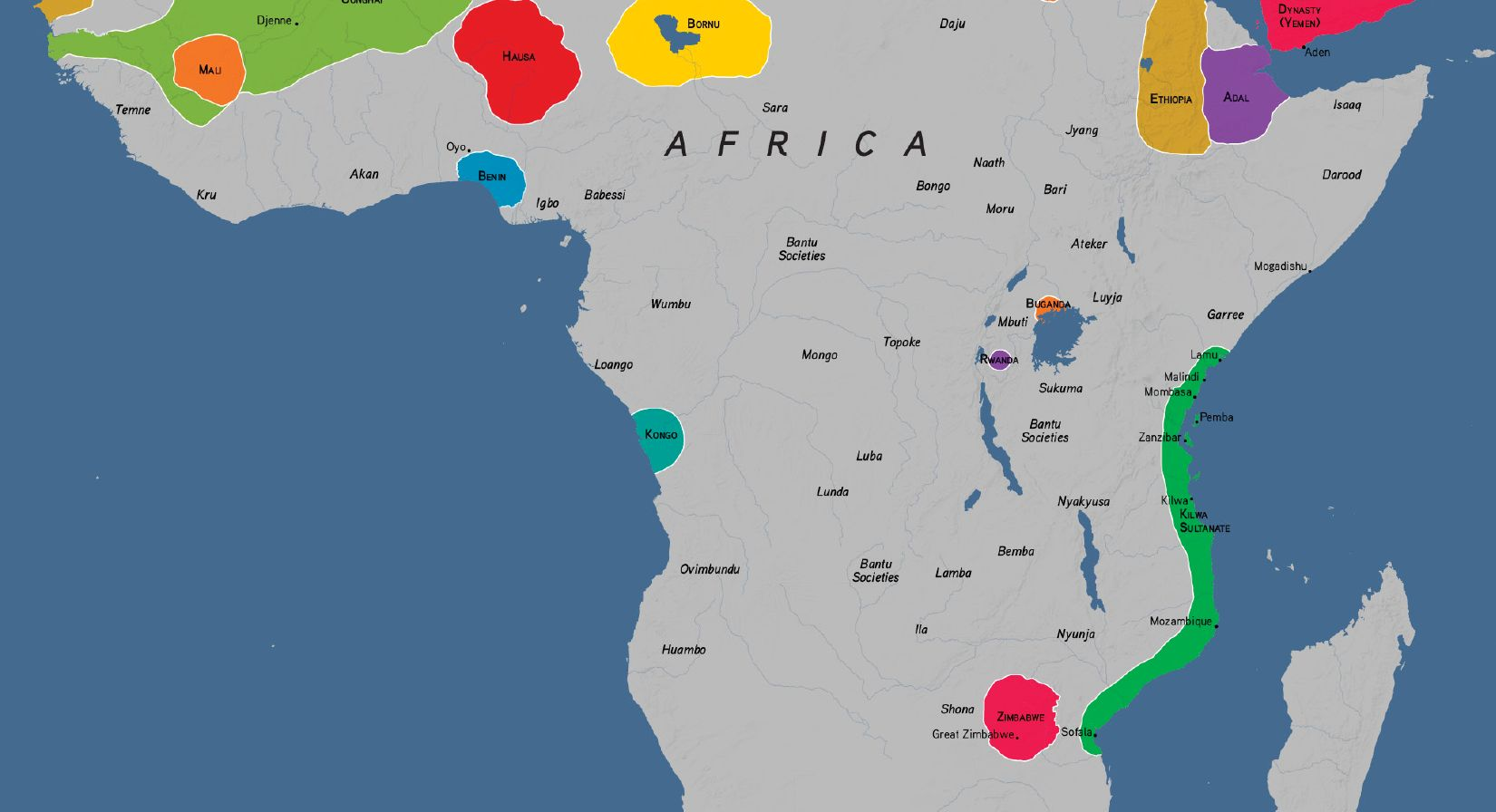
Notable Places
- Timbuktu (Mali)
- Ethiopia
- Great Zimbabwe
- Swahili Coast
Notable People
- Sundiata Keita (Founder of Mali Empire)
- Ibn Battuta (Moroccan Islamic Traveller)
- Ibn Khaldun (Arab Historian and Philosopher)
- Mansa Musa (Wealthy Musa of Mali)
- Zhenghe (Chinese Islamic Navigator)
Notable Trade, Travel, and Pilgrimage Routes
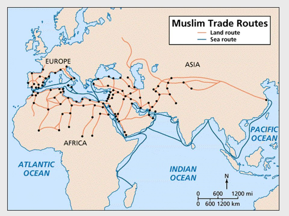
- Trans-Saharan Trade Route
- Portuguese Voyages
- Mansa Musa’s Pilgrimage
- Indian Ocean Trade
Part 1: Notable Places
Part 1.1: Mali Empire
MALI was founded by Sundiata Keita (basis for the Lion King.

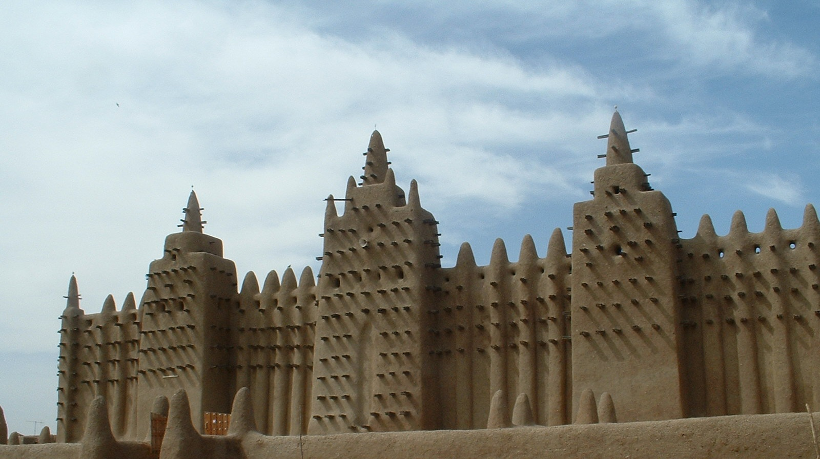
The Mali Empire was an empire in West Africa from c. 1226 to 1670. The empire was founded by Sundiata Keita (c. 1214 – c. 1255) and became renowned for the wealth of its rulers, especially Mansa Musa (Musa Keita). At its peak, Mali was the largest empire in West Africa, widely influencing the culture of the region through the spread of its language, laws, and customs.
While the empire began as a small Mandinka kingdom at the upper reaches of the Niger River, the conquest of Sosso (The Battle of Kirina) in c. 1235 marked the emergence of Mali as a major power.
The Battle of Kirina, c. 1235, was a confrontation between Sosso king Sumanguru Kanté and Mandinka prince Sundiata Keita. Sundiata Keita’s forces roundly defeated those of Sumanguru Kanté, guaranteeing the pre-eminence of Keita’s new Mali Empire over West Africa.
Following the death of Sundiata Keita in c. 1255, the kings of Mali were referred to by the title mansa.
The Sundiata (Sunjata) is an epic poem of the Malinke people that tells the story of the hero Sundiata Keita, the founder of the Mali Empire. It is very long. He was known as the Lion King of Mali and is the basis for the movie ‘The Lion King. The story comes from the oral tradition of story telling, meaning there is no one definitive version as it wasn’t written down at the time. The link above is a translated version.
Part 1.2: Great Zimbabwe
Take a look at these pictures first.
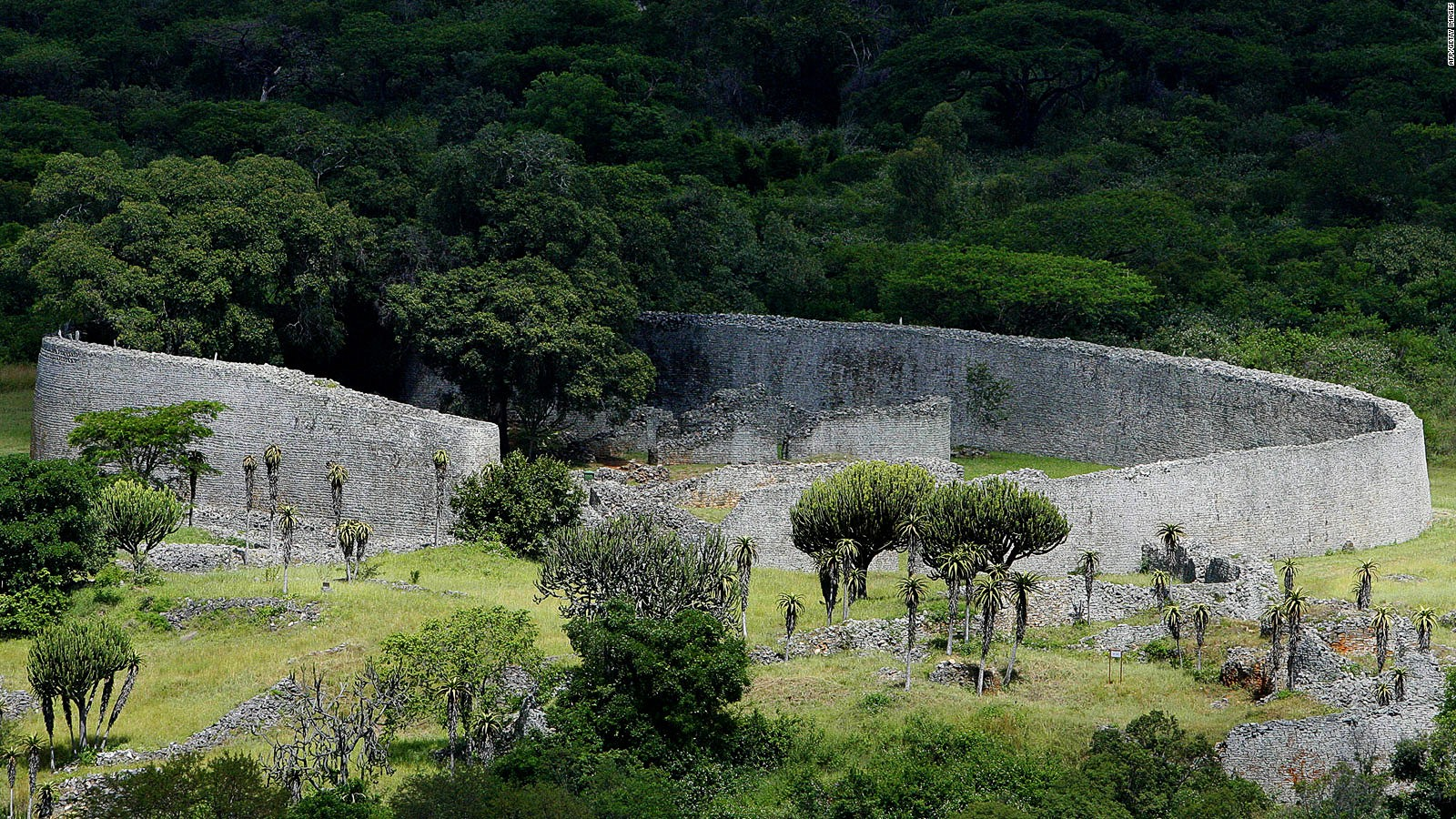
The ruins of the city of Great Zimbabwe, the monumental capital of the Kingdom of Zimbabwe, are one of the most emblematic places of the world’s architectural heritage. The name of the site derives from a Shona word meaning “stone house,” and it is the largest of the over 300 zimbabwe sites across the country. A national monument and a UNESCO World Heritage Site, Great Zimbabwe encompasses extensive areas of archaeological remains, including the Hill Complex, a granite acropolis that was occupied for centuries; the iconic Great Enclosure, the largest ancient structure to be built in sub-Saharan Africa; and the Valley Ruins, which comprise a series of residential ensembles that were occupied more recently in the site’s history.
At the peak of the Kingdom of Zimbabwe in the fourteenth century, the city was home to a population of more than 10,000. After the fifteenth century, the city was gradually abandoned and fell into ruin. Today, the archaeological landscape is a site of great significance for the modern nation of Zimbabwe, serving as a national symbol and a link with its pre-colonial past. It also holds great significance for local communities of the Charumbira, Mugabe, Murinye, and Nemanwa clans, whose lineage is intertwined with the history of the site.
(From:https://www.wmf.org/project/great-zimbabwe)
Activity
Locate the the ruins of the city of Great Zimbabwe on Google Maps or Google Earth or a similar mapping system. Go into satellite view, remove labels, and screen shot the monuments and ruins. Find some photos of the monuments by doing a ‘walk through’ and screen shot or save them. Create a poster connecting the monument pictures to the area map.
Part 1.3: Ethiopia

Ethiopia, officially the Federal Democratic Republic of Ethiopia, is a landlocked country located in the Horn of Africa region of East Africa. It shares borders with Eritrea to the north, Djibouti to the northeast, Somalia to the Northeast, East and Southeast, Kenya to the South, South Sudan to the West, and Sudan to the Northwest.
Ethiopia covers a land area of 1,112,000 square kilometres (472,000 sq. miles). As of 2023, it is home to around 128 million inhabitants, making it the 13th-most populous country in the world, the 2nd-most populous in Africa after Nigeria, and the most populated landlocked country on Earth.
The Ethiopian Empire, also formerly known as Abyssinia, or simply known as Ethiopia,was a sovereign state that historically encompasses the geographical area of present-day Ethiopia and Eritrea.
It was established during the Solomonic dynasty by Yekuno Amlak in approximately 1270.
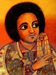
In 1974 there was a coup d’etat (a sudden, violent, and unlawful seizure of power from a government) by the Derg (officially the Provisional Military Administrative Council (PMAC) was the Marxist–Leninist military dictatorship that ruled Ethiopia, then including present-day Eritrea, from 1974 to 1987,). This coup dethroned Emperor Haile Selassie (major figure of Rastafari, a religious movement in Jamaica that emerged shortly after he became emperor in the 1930s.)
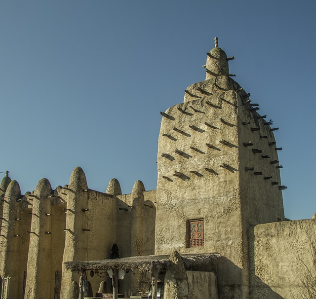
Part 1.4: The Swahili Coast
The Swahili Coast of the Southeast connects Africa to the Indian Ocean trade and thus, South Asia, Southeast Asia, and China.
The Swahili coast is a coastal area of East Africa, bordered by the Indian Ocean and inhabited by the Swahili people. It includes Sofala (located in Mozambique); Mombasa, Gede, Pate Island, Lamu, and Malindi (in Kenya); and Dar es Salaam and Kilwa (in Tanzania). In addition, several coastal islands are included in the Swahili coast, such as Zanzibar and Comoros.
This coastal region is home to a unique culture and language—a multicultural polyglot of African, Arab, and Indian Ocean peoples.
The original inhabitants of the Swahili Coast were Bantu-speaking Africans, who had migrated east from the continent’s interior. They eventually spread up and down the coast, trading with each other, with the people of the interior, and eventually people from other continents.
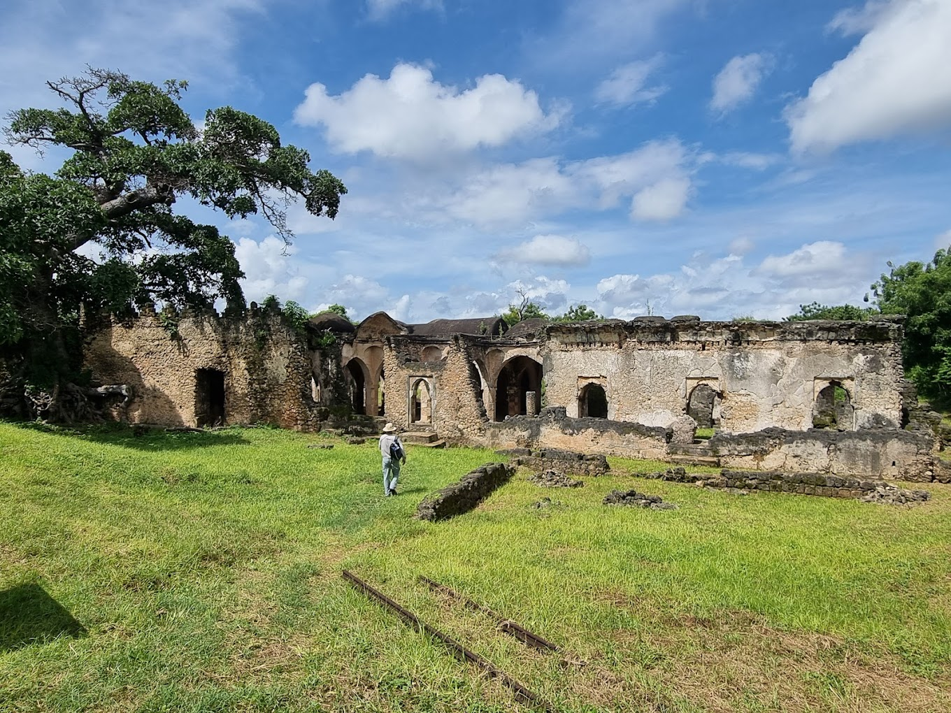
The Swahili Coast appears to have reached its zenith during the Medieval Period, from around the 11th to 15th centuries. During that time, the Swahili Coast comprised numerous city-states that traded across the Indian Ocean. The city-states were independent sultanates, although they shared a common language (Swahili) and religion (Islam). They traded across the Indian Ocean for items, such as pottery, silks, and glassware.
Collectively, the city-states are often referred to as “stone towns,” because many buildings were constructed using stone—coral blocks held together with mortar. One of the larger structures, whose ruins remain today, is a stone mosque in the city of Kilwa.
(Adapted from: https://education.nationalgeographic.org/resource/people-coast/)
These photos were taken of the peoples of the area.
Part 2: Notable People
Part 2.1: Mansa Musa
Mansa Musa is globally the most famous person from Africa in this period.
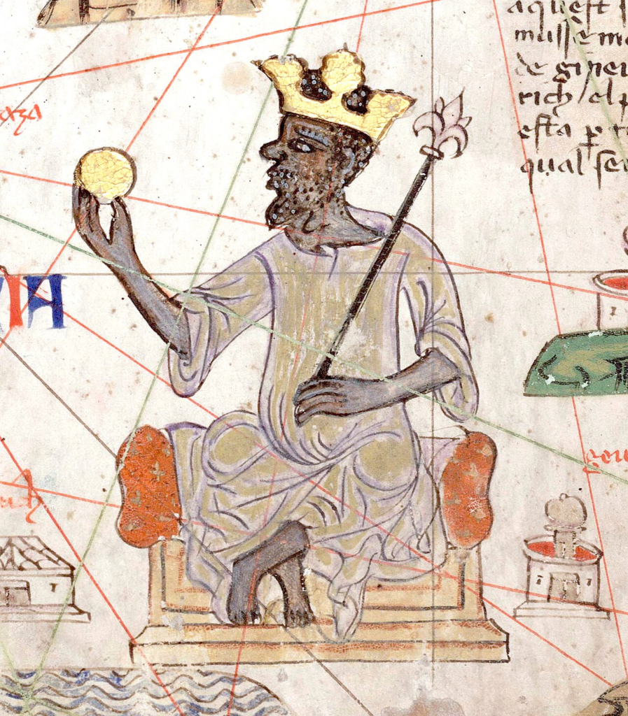
Mansa Musa (reigned c. 1312 – c. 1337) was the ninth Mansa (hereditary ruler / king) of the Mali Empire, which reached its territorial peak during his reign. Musa’s reign is often regarded as the zenith of Mali’s power and prestige.
He was extremely wealthy; it has been suggested that he was the wealthiest person in history, but the extent of his actual wealth is not known with any certainty. It is known from local manuscripts and travellers accounts that Mansa Musa’s wealth came principally from the Mali Empire controlling and taxing the trade in salt from northern regions and especially from gold panned and mined in the gold-rich regions to the south.
(From: https://en.wikipedia.org/wiki/Mansa_Musa)
Part 3: Notable Routes
Part 3.1: Trans-Saharan Salt-Gold Trade Route
Trans-Saharan Trade, also known as the Gold-Salt Trade, was an extensive network of trade routes that linked the Mediterranean world with West Africa during the Middle Ages. The trade routes facilitated the exchange of goods, ideas, and cultures between the people of Europe, the Middle East, and Africa.
Part 3.1.1: The Camel Saddle
Until the widespread domestication of the camel in the early centuries of the Common Era, historians believe, trans-Saharan trade and exchange was quite rare. Camels are ideal for Saharan movement: they rarely sweat, even in hot desert climates, and can conserve fluids for long periods of time. With camels to ride and to carry loads, the Tuareg and other Imazighen peoples of the Sahara once controlled the caravan routes that stretched across the desert. Their economy was based on herding and supplemented by the trade of salt. Tuareg nobility depended on artisans to produce wood, metal, and leather goods like this saddle.
Part 3.1.2: Salt
Salt was a highly valued commodity not only because it was unobtainable in the sub-Saharan region but because it was constantly consumed and supply never quite met the total demand. There was also the problem that such a bulky item cost more to transport in significant quantities, which only added to its high price.
Part 3.1.3: Gold
The Sahara Desert was a thriving crossroads of exchange for West Africa, North Africa, the Middle East, and Europe in the medieval period. Fueling this exchange was West African gold, prized for its purity and used for minting currencies and adorning luxury objects such as jewelry, textiles, and religious objects.
Activity
Use this map to explore the trans-saharan trade routes and places (marked in yellow). On your own map draw them out and label them. Feel free to add in any other information that you have learned about the salt and gold trade. You can use one of the maps below, find or draw your own, or use an online mapping program.
Part 3.2: Portuguese Voyages
In 1415, the Portuguese occupied the North African city of Ceuta to gain a foothold in Morocco and control shipping through the Strait of Gibraltar. Among the participants of the action was the young Prince Henry the Navigator. Appointed governor of the Order of Christ in 1420, while personally holding profitable monopolies on resources in Algarve, he took the lead role in encouraging Portuguese maritime exploration until his death in 1460.
At around the same time as an unsuccessful attack on the Canary Islands, the Portuguese began to explore the North African coast. Sailors feared what lay beyond Cape Bojador at the time, as Europeans did not know what lay beyond on the African coast, and did not know whether it was possible to return once it was passed. Henry wished to know how far the Muslim territories in Africa extended, and whether it was possible to reach the source of the lucrative tran-Saharan caravan gold trade.
Activity
Use this map to explore the portuguese voyages and places (marked in purple). On your map draw them out and label them. Feel free to add in any other information that you have learned about the voyages.
Part 3.3: Indian Ocean Trading Routes
From 1200 to 1450, the Indian Ocean was the center of world trade. The world’s largest empires traded in this diverse network of merchants from all over Afro-Eurasia.
From 1200 to 1450, the Indian Ocean was the center of world trade. Trade routes crossed the waves, linking the South China Sea to the Indian Ocean to the Mediterranean Sea. Peoples and languages mingled in the great trading cities along the shores of the Indian Ocean. Luxuries like Chinese porcelain and silk, East African gold and ivory, and Southeast Asian spices like cinnamon, clove, nutmeg, and mace were in high demand far from where they were produced. Traveling thousands of miles from merchant to merchant, port to port, these goods made their way through the network, their prices increasing the further they traveled.
(From: https://www.khanacademy.org/humanities/world-history-project-ap/xb41992e0ff5e0f09:unit-2-networks-of-exchange/xb41992e0ff5e0f09:2-2routes-of-exchange/a/read-indian-ocean-routes)
Swahili Coast Trading
A large variety of products were traded in the cities of the Swahili coast: gold, iron, copper, salt, valuable hardwoods such as ebony and sandalwood, ivory, tortoise shells for making decorative objects like combs, and animal hides. These goods were brought overland across trade routes from the African interior and then were either purchased by the cities’ inhabitants for their own use or resold elsewhere in Africa or in Arabia, Persia, and India. From these places, the goods might travel even farther to Southeast Asia or China. Artisans in the cities crafted pottery and wove cloth that became part of the trade too and were sold in Africa or overseas. The goods of Asia also flowed into these cities, and the elites of the Swahili coast adorned themselves with glass beads from India, dressed in Chinese silks, and ate from Chinese porcelain. Some merchants embedded pieces of porcelain in the walls of their homes for decoration.
(From: https://openstax.org/books/world-history-volume-2/pages/3-3-the-swahili-coast)
Part 3.3.1: Ivory
Extra reading and questions here.
Part 3.3.2: Copper
Further reading in this article.
Part 3.3.3: Iron
Africa’s Iron Origins: Archeological Evidence
Part 3.3.4: Cereals
More (extensive – be picky) here.
Activity
The Indian Ocean Trade
Instructions:
You own a trading company in the year 1324. The merchants working for your company are from East Africa and Asia.
The object of the simulation is to make as much profit as you can by traveling back and forth across the Indian Ocean and conducting trade between Asian and African kingdoms. Use the Price List below as a guide. This is a turn-taking simulation.
Rules:
- You may begin in either Asia or Africa.
- You start out with 5 gold coins.
- You have a total of TWO ROUND TRIPS—that’s four one-way trips across the Indian Ocean.
- You need to keep track of the company’s profits and losses step by step. Use the Balance Sheet to do this.
- If you go into debt, the company is out of business and your turn is over.